Whippets Brook
The U3A geology group had a field trip to Whippets Brook, on the Northern end of the Malvern Hills, on Wednesday 3rd June 2009.
The trip leader was Richard Edwards who is well known to the group, having lectured to us over two winter seasons.
The primary purpose of the trip was to understand the geology surrounding the Whippets Brook area. With this aim, we first looked at the structural evolution of the Malvern Hills, in particular their faulting. With this aim, the trip was split into two parts.
Tank Quarry
The structural evolution of the Malvern Hills was discussed. The generation of the hills we see today can be thought of as a two stage process.
1. Firstly a thrusting action which resulted in the deformation of the older Precambrian rocks. This occurred during the late Carboniferous period era, raising them up from some depth.
This thrusting was a part of the Variscan orogeny (a mountain-building event). NW directed pressure was converted into westerly directed deformation by localised changes in the stress regime, probably due to the influence of a major N-S trending weakness in the earth's crust.
This reflects a major boundary between blocks of early crust which converged in late Silurian times. This boundary has acted as a zone of weakness during later geological history.
2. The second stage was a pulling apart which happened 20 to 30 million years later in the Permian or Triassic period. This pulling apart formed the Worcester Basin. This basin is a rift valley, the Westerly edge of it being the East Malvern Fault. The valley was then subsequently filled with sediments of Triassic age.
Then we discussed the extent of the East Malvern fault. Richard showed us a post card showing the rock density around the British Isles, created using gravity anomaly mapping. This clearly showed a West/East step increase in rock density along a 300 mile line, starting at the South coast, running through Malvern and ending in Cheshire.
We then examined the East Malvern Fault, clearly visible above the car park at Tank Quarry (grid reference SO 768470).

A part of the East Malvern Fault. The rock above is Precambrian, inclined at about 45 degrees. The rocks below are Triassic. At the fault it is possible to see a shiny zone with striations. These are called slickensides and are caused by the movement of rocks along the two sides of a fault.

Just to the right of the previous stop we saw a fault breccia. In it the Malvernian Precambrian rock is broken up into small fragments. This breccia can be caused when rock is crushed, as here, in a tangential compression fault.
We then walked along the path to the left of the Clock Tower to the reservoir (grid reference SO 769471), stopping to admire the view.

Walking up the steps to the reservoir we saw a xenolith in one of the steps. A xenolith is a foreign rock fragment which has become enveloped into a younger and larger rock during the latter’s development and hardening. Here we have a xenolith of igneous origin, granite veins within diorite. Richard explained that what may have happened was that an earlier piece of granite had broken off during the cooling of a diorite magma chamber. He said this was unusual; normally one finds a diorite xenolith within granite.
Richard was asked about the difference between granite and diorite. The key difference is the presence of quartz; granite has 20% plus quartz whereas diorite has little or none. If present, feldspars tend to be potassium rich in granite, calcium rich in diorite. Any ferromags are biotite in granite, hornblend in diorite.

On the way up we stopped to admire the view looking across the Worcester Basin. This basin was formed by the pulling apart and subsequent sinking of the land. Two roughly parallel sets of faults, running in a North South direction, were responsible: the East Malvern Fault to the West and a similar set running through Inkberrow to the East. This rift valley was eventually filled with Triassic sediments.
We then arrived at the reservoir and examined the fault there. This fault runs roughly East to West. Faults in this direction have been very important during the formation of the Malvern Hills. Over time they have weakened the hills, forming valleys and splitting the hills into discrete blocks.
Examining the fault in detail, it can be seen that it has been formed with a different process compared to the previous fault. There is a one metre wide crush zone creating a grinding action within the rocks. Rocks are sheared into elongated blocks as shown. Compared with the rocks in the previous fault’s breccia, it is now hard to distinguish the different constituents making up the rock (e.g. diorite or granite) due to this crushing and grinding action.
Whippets Brook
For the second part of the trip we assembled in the small car park at the intersection of the B4219 and the Worcester Way (grid reference SO 766476, (a) on the map). See the map below.
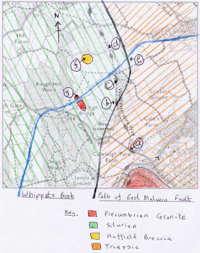
Richard explained what he hoped to show us. First we would walk North along the Worcester Way and see the Silurian landscape to the West. These Silurian hills are around 420 million years old and have been folded and faulted by the same processes that thrust up the Malvern Hills.
Although we saw the East Malvern Fault at the quarry earlier, we had not yet seen the Triassic to the East. Also, within the Silurian, he planned to show us some Haffield Breccia and a fragment of Malvernian Precambrian rock.

We walked North, with the Worcester Basin to our right. Stopping at point (b) on the map, Richard said we were walking across the fault plane with Silurian Lower Ludlow Shale to the West and ahead, and Triassic to the East and behind. These were formed in very different environments, the Silurian in marine conditions and the Triassic in a desert.

We stopped where there was a path to the right, just before the bridge, (c) on the map. Richard pointed out a small outcrop of limestone, and said this was the only limestone outcrop he had found in the area. One can see that the bedding plane dips down. The geological map stated this is Much Wenlock Limestone with a 42 degree dip to the East.
We continued across the bridge over Whippets Brook, going North along the Worcestershire Way to point (d) on the map.

Looking West we could see Rough Hill Wood. The rock to the right of the summit is underlain by Haffield Breccia, which is Permian in age. Richard pointed out that the hill in this area had brownish tinge to it, contrasting with the bright green around it. He explained that this is due to the sparseness of the vegetation around the Breccia, caused by the very thin soil cover. We will find an outcrop of the Breccia later.
We returned to the bridge and turned East, following the Brook to point (e) on the map.
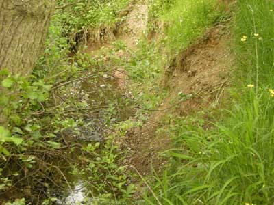
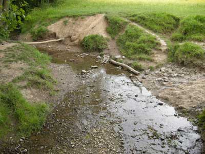
This point in the stream is where there is a change from Silurian to Triassic. Richard said that streams tend to be good for finding outcrops, but he was unable to find any Silurian outcrops here. However, he did find an outcrop of Triassic clays here, which he said was most unusual in the area.
The small waterfall here represents the change from the hard Silurian limestone to the orange muddy soft Triassic clays, as well as the fault.
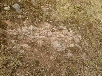
We then went West, climbing the hill to point (f) on the map, to see the outcrop of Haffield Breccia.
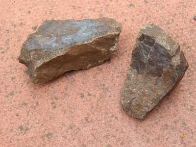
Richard compared and contrasted this with the piece of Haffield Breccia that he had from our field trip to Leigh Brook earlier in the year (19 March 2009), shown below.
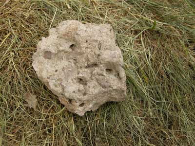
Each Breccia is composed of very angular igneous material called clasts. The clasts are cemented together in some manner. The two examples are quite different, each giving clues to the different environments in which they were formed. The example from Leigh Brook has very angular clasts floating in a very solid matrix, indicating no movement. It was noted it was dense and like concrete. The sample we had just found had less angular clasts, more like pebbles and had some sense of bedding. Richard assumed it must have been moved by a stream at some point.
The age of the breccia was considered. As it contain no fossils this is difficult to determine. Dating the earlier igneous material by radiometric means is of no help. The jury appear to be out with the Haffield Breccia, suggestions of Carboniferous, Permian or Triassic age mooted.
Richard was asked about the difference between a breccia and a conglomerate. He said it is basically the shape of the clasts, a breccia has angular clasts and a conglomerate rounded ones. He thought the Whippets Brook one here was close to being a conglomerate with its partially rounded clasts. Geologists have a term for clasts with both angular and rounded clasts he told us, a breccio- conglomerate.
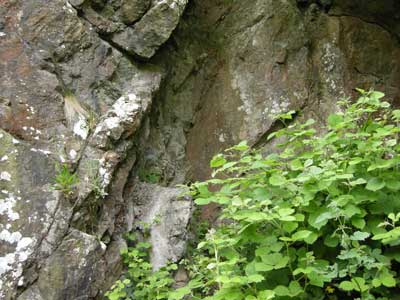
We then moved West to point (g) on the map to examine a small outcrop of granite.
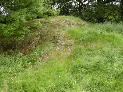
There are two sizable outcrops of granite in this area, forming a lens on either side if Whippets Brook. The one on the Northern side is shown here. Interestingly there is no granite in the stream bed. Richard suggested there had originally been a fault in the granite which the stream had occupied. What had been on top of the granite originally remains a mystery, and has been eroded over time.
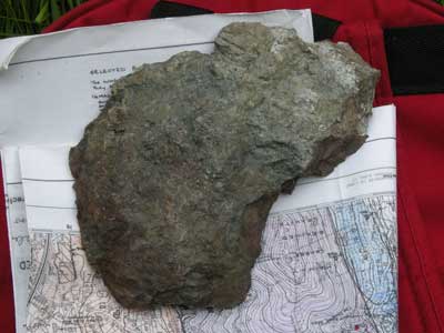
Richard chipped a bit off the outcrop: (see below).
Note the blackened and weathered surface and the difficulty in seeing the granite structure. Compare this with the granite rock sample we got an Tank Quarry earlier which had a fresh, pink appearance. Richard suggested the rock may have been overlain by Haffield Breccia, which has since been worn away. He said that when the area was first geologically mapped by John Phillips in 1857 there was indeed Haffield Breccia 100 yards from this point, which has since been eroded.
Finally, Richard summarised what we had seen on the field trip. The evolution of the area started with a thrusting action from the East, which thrust up the Malvern Hills to the surface where we see them today. This thrusting also folded the Silurian rocks and faulted them. Finally there followed a pulling apart creating the Worcester Basin, a 2 Km deep valley was filled with Triassic sandstone.